Students discover fluid dynamics related to buoyancy through experimentation and optional photography. …
Students discover fluid dynamics related to buoyancy through experimentation and optional photography. Using one set of fluids, they make light fluids rise through denser fluids. Using another set, they make dense fluids sink through a lighter fluid. In both cases, they see and record beautiful fluid motion. Activities are also suitable as class demonstrations. The natural beauty of fluid flow opens the door to seeing the beauty of physics in general.
Focusing on air, water, land and life, this video describes how these …
Focusing on air, water, land and life, this video describes how these components are connected in the Earth system through the flow of energy, cycles of water and biogeochemistry. Methods of studying the Earth system, ranging from field observations to analysis of satellite images are discussed. This video is one of the 24-part instructional video series describing scientific protocols used by GLOBE (Global Learning and Observation to Benefit the Environment), a worldwide, hands-on, K-12 school-based science education program.
This video highlights students taking scientific measurements to support investigations in atmospheric …
This video highlights students taking scientific measurements to support investigations in atmospheric science, hydrology, soils, and land cover. It shows students reporting data through the Web, creating scientific visualizations for analysis, and collaborating with students and scientists around the world. This is one two introductory videos in the 24-part GLOBE video series. GLOBE (Global Learning and Observation to Benefit the Environment) is a worldwide, hands-on, K-12 school-based science education program.
This video highlights students taking scientific measurements to support investigations in atmospheric …
This video highlights students taking scientific measurements to support investigations in atmospheric science, hydrology, soils, and land cover. It shows students reporting data through the Web, creating scientific visualizations for analysis, and collaborating with students and scientists around the world. This is one of two introductory videos in the 24-part GLOBE video series. GLOBE (Global Learning and Observation to Benefit the Environment) is a worldwide, hands-on, K-12 school-based science education program.
This video demonstrates students locating and preparing a study site where they …
This video demonstrates students locating and preparing a study site where they can conduct field observations. The procedure used when describing a soil profile is outlined. The properties of soil are described, including the structure, color, consistence, and texture, as well as the presence of roots, rocks and free carbonates. Safety precautions are stressed. The resource includes a video and a written transcript, and is supported by the Soil Characterization, Field Measurement Protocol in the GLOBE Teacher Guide. This is one of five videos about soils in the 24-part instructional video series describing scientific protocols used by GLOBE (Global Learning and Observation to Benefit the Environment) a worldwide, hands-on, K-12 school-based science education program.
This video describes how to select a soil infiltration study site, and …
This video describes how to select a soil infiltration study site, and demonstrates procedures used when taking soil infiltration in the field. Instructions for fabricating a necessary piece of field equipment, a dual-ring soil infiltrometer, are provided. The resource includes a video and a written transcript, and is supported by the Soil Infiltration Protocol in the GLOBE Teacher's Guide. This is one of five videos about soils in the 24-part instructional video series describing scientific protocols used by GLOBE (Global Learning and Observation to Benefit the Environment) a worldwide, hands-on, K-12 school-based science education program.
This video describes how to select a soil moisture study site and …
This video describes how to select a soil moisture study site and sampling strategy, and identifies what laboratory instruments will be needed to complete a soil moisture analysis. Students are shown collecting soil moisture data and asking questions about what soil moisture data might tell them about the environment. The resource includes a video and a written transcript, and is supported by the Soil Moisture Protocol in the GLOBE Teacher's Guide. This is one of five videos about soils in the 24-part instructional video series describing scientific protocols used by GLOBE (Global Learning and Observation to Benefit the Environment), a worldwide, hands-on, K-12 school-based science education program.
Gale Academic OneFile Select is a cross-disciplinary research database (science, literature, history, …
Gale Academic OneFile Select is a cross-disciplinary research database (science, literature, history, etc.). Students can search over 5,000 journals, magazines and newspapers. The database also includes multimedia content.
How do greenhouse gases affect the climate? Explore the atmosphere during the …
How do greenhouse gases affect the climate? Explore the atmosphere during the ice age and today. What happens when you add clouds? Change the greenhouse gas concentration and see how the temperature changes. Then compare to the effect of glass panes. Zoom in and see how light interacts with molecules. Do all atmospheric gases contribute to the greenhouse effect?
The marine environment is unique and requires technologies that can use sound …
The marine environment is unique and requires technologies that can use sound to gather information since there is little light underwater. The sea-floor is characterized using underwater sound and acoustical systems. Current technological innovations are allowing scientists to further understand and apply information about animal locations and habitat. Remote sensing and exploration with underwater vehicles allows scientists to map and understand the sea floor, and in some cases, the water column. In this lesson, the students will be shown benthic habitat images produced by GIS. These imaged will lead to a class discussion on why habitat mapping is useful and how current technology works to make bathymetry mapping possible. The teacher will then ask inquiry-based questions to have students brainstorm about the importance of bathymetry mapping.
This is a lesson about geologic history. Learners will work together to …
This is a lesson about geologic history. Learners will work together to create models of volcanic lava flows and analyze the layers that form on a planet's surface. They will sequence lava flows produced by multiple eruptions. Students will be asked to observe where the flows travel, make a model, and interpret the stratigraphy. Students will use their volcanic layering model to demonstrate the relative dating and geologic mapping principles to later be applied to satellite imagery. The lesson models scientific inquiry using the 5E instructional model and includes teacher notes and vocabulary.
The purpose of NASA's Earth Observatory is to provide a freely accessible …
The purpose of NASA's Earth Observatory is to provide a freely accessible publication on the Internet where the public can obtain new satellite imagery and scientific information about our home planet. The focus is on Earth's climate and environmental change. The site is divided into six main sections: Data and Images, Features, News, Reference, Missions, and Experiments. The Data and Images, Features, and Reference sections are each subdivided into sections for Atmosphere, Oceans, Land, Life on Earth, and Heat and Energy. The missions section explains all of the current NASA missions, and the Experiments section contains activities related to the topics covered in the other sections. Information provided in these pages includes text, photographs, animations, maps, and datasets. The site also includes a glossary, "ask a scientist" feature, and links to current news stories.
This page, from National Aeronautics and Space Administration's Earth Observatory, contains a …
This page, from National Aeronautics and Space Administration's Earth Observatory, contains a satellite image of the mouth of the Mississippi River and the nearby Gulf of Mexico. The sediment carried by the river following a rainstorm is clearly evident as it mixes with the dark blue water. The site also contains links to the Newsroom and other recent images.
The purpose of NASA's Earth Observatory is to provide a freely-accessible publication …
The purpose of NASA's Earth Observatory is to provide a freely-accessible publication on the Internet where the public can obtain new satellite imagery and scientific information about our home planet. The specific focus of this Earth Observatory website is natural hazards. Earth scientists around the world use NASA satellite imagery to better understand the causes and effects of natural hazards. The goal in sharing these images is to help people visualize where and when natural hazards occur, and to help mitigate their effects. Natural hazards that are emphasized include dust and smoke, wildfires, floods, severe storms, and volcanoes. In addition, each week the site highlights major natural hazard events occurring around the globe. Links to satellite imagery and informational text concerning the natural hazard and image interpretation are included. The site also offers a link to unique imagery, such as earthquakes, droughts, and landslides, and features the latest unique imagery events around the globe.
This webpage, one of NASA's fact sheets, describes the role of the …
This webpage, one of NASA's fact sheets, describes the role of the oceans, clouds, and aerosols in moderating climate, which has resulted in less-than-expected temperature increases as carbon dioxide levels have increased. It also describes the efforts of scientists to construct computer models to understand interactions between the atmosphere and ocean, and to perform space-based oceanography using the Earth Observing System (EOS). The site features text, pictures, and links to other relevant NASA sites.
This free, online article, developed for elementary teachers, describes a Kindergarten polar …
This free, online article, developed for elementary teachers, describes a Kindergarten polar science, standards aligned, unit centered on The Polar Express developing literacy, math, and science skills.
In this lesson, students analyze land cover change in order to help …
In this lesson, students analyze land cover change in order to help them grasp the extent, significance, and consequences of land cover change; and to introduce them to the perspective of space-based Earth observations. Students learn to identify kinds of land cover (such as roads, fields, urban areas, and lakes) in Landsat satellite images. They decide which land cover types allow the passage of water into the soil (pervious) and which types do not allow it (impervious). They consider some effects of increasing impervious surface area on ecosystem health. Students then make land cover maps using two Landsat satellite images taken about a decade apart, and quantify the change of land cover from pervious to impervious surface. They also make predictive maps of what they think the nature and extent of land cover change in the area will be in the year 2025, and speculate about the consequences for the availability of water for people and ecosystems. Students justify in writing their predictive maps and their thoughts about the consequences of change. This activity uses Landsat images of Phoenix, Arizona; links are also provided for finding Landsat images of other cities.
The discovery of restriction enzymes and their applications in DNA analysis has …
The discovery of restriction enzymes and their applications in DNA analysis has proven to be essential for biologists and chemists. This lesson focuses on restriction enzymes and their applications to DNA analysis and DNA fingerprinting. Use this lesson and its associated activity in conjunction with biology lessons on DNA analysis and DNA replication.
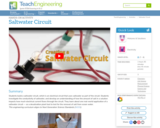
Students build a saltwater circuit, which is an electrical circuit that uses …
Students build a saltwater circuit, which is an electrical circuit that uses saltwater as part of the circuit. Students investigate the conductivity of saltwater, and develop an understanding of how the amount of salt in a solution impacts how much electrical current flows through the circuit. They learn about one real-world application of a saltwater circuit — as a desalination plant tool to test for the removal of salt from ocean water.
No restrictions on your remixing, redistributing, or making derivative works. Give credit to the author, as required.
Your remixing, redistributing, or making derivatives works comes with some restrictions, including how it is shared.
Your redistributing comes with some restrictions. Do not remix or make derivative works.
Most restrictive license type. Prohibits most uses, sharing, and any changes.
Copyrighted materials, available under Fair Use and the TEACH Act for US-based educators, or other custom arrangements. Go to the resource provider to see their individual restrictions.