An interactive map based on four decades of satellite images helps residents, …
An interactive map based on four decades of satellite images helps residents, resource managers, and stewards of the land anticipate and plan for coastal change.
This site offers 5,390+ robust, original stories based on primary sources and …
This site offers 5,390+ robust, original stories based on primary sources and presented in various media formats: written, dramatized narrations, videos, images, maps, and more! Free stories each day are available for access - see the home page and the What Matters Now tabs
In this lesson, students learn that navigational techniques change when people travel …
In this lesson, students learn that navigational techniques change when people travel to different places land, sea, air and in space. For example, an explorer traveling by land uses different methods of navigation than a sailor or an astronaut.
If you’re looking for some apps for the tablet, we recommend DuckDuckMoose …
If you’re looking for some apps for the tablet, we recommend DuckDuckMoose for the preschool to kindergarten set. Graphics and interface are engaging and easily accessible for children. From puzzles, maps, to fun music apps where you can learn notes and rhythm, kids gravitate enthusiastically to this sister site of Khan Academy.
"Explore History is your gateway to a world-class collection of primary sources …
"Explore History is your gateway to a world-class collection of primary sources – maps, photos, newspapers, manuscripts, pamphlets, portraits and more.
Explore the lives and history of Indigenous Peoples, British actors and musicians, as well as members of the LGBTQ2S+ community. Check out periodicals such as The Economist and The Times. This initiative will further research, teaching and lifelong learning in Saskatchewan.
All Saskatchewan residents enjoy unrestricted access to these collections thanks to the Dr. John Archer Library, University of Regina with the assistance of the University of Saskatchewan Library and the Regina Public Library.
If you have questions about these resources, contact your local library."
"Educators and students across Canada can access ArcGIS software, support and teaching resources for free. All our resources are licensed under Creative Commons Attribution-NonCommercial-ShareAlike 4.0 International, and we encourage educators to share and adapt our resources to work with their courses.
ArcGIS is a powerful tool for learning in social studies for various reasons. It allows students to tell stories by visualizing, analyzing, and interpreting data related to location and place. This can be incredibly valuable in social studies, where understanding the spatial relationships between historical events, cultural phenomena, and natural resources can help students develop a deeper and more nuanced understanding of the world around them. Check it out"
Students will begin to understand the concept of maps by describing the …
Students will begin to understand the concept of maps by describing the path that Little Red Riding Hood took on the way to Grandma's house. Main Curriculum Tie: Social Studies - Kindergarten, Standard 3 Objective 1, Identify geographic terms that describe their surroundings. Many fairy tales and nursery rhymes take the characters on a path through the rhyme/story. In this lesson, we will be making up maps for the characters to follow. In the first activity, the class will be recreating a map of the path that Little Red Riding Hood takes to Grandma’s house. The students will be exploring basic map directions and characteristics.
"Become a geography expert and have fun at the same time! Seterra …
"Become a geography expert and have fun at the same time! Seterra is an entertaining and educational geography game that gives you access to over 400 customizable quizzes.
Seterra will challenge you with quizzes about countries, capitals, flags, oceans, lakes and more! Introduced in 1997 and available in 36 different languages, Seterra has helped thousands of people study geography and learn about their world."
"The Core Knowledge Foundation provides open access to content-rich curriculum materials for …
"The Core Knowledge Foundation provides open access to content-rich curriculum materials for preschool through grade 8, including the Core Knowledge Curriculum Series™, with many materials now available and many more in development."
You will need to provide your email address to download these amazing resources. CK has aligned their ELA to the Science of Reading in collaboration with Amplify Reading. *Full Units *Books for Students *Teaching Materials *Scope & Sequence
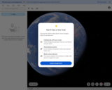
Zoom over the Sahara desert. Take a tour of the Eiffel Tower. …
Zoom over the Sahara desert. Take a tour of the Eiffel Tower. You can do it all with Google Earth, the tool that makes the world feel a little bit smaller with its map-generating capabilities. If you're new to Google Earth, the tutorials offer a great introduction.
*Guided tours with the Voyager option. Take a guided tour around the globe with some of the world's leading storytellers, scientists, and nonprofits. Immerse yourself in new cultures and test your knowledge of the world.
*Measure distances & area
*Take your students virtually to the place you are studying
Street View Treks gives a first-person view to some of the most …
Street View Treks gives a first-person view to some of the most spectacular locations in the world, from Mount Fuji to the Grand Canyon to the Taj Mahal in India. Check out the maps, 360 panoramic images and videos.
This project is a year long in-depth inquiry project into the Pacific …
This project is a year long in-depth inquiry project into the Pacific Rim Region and is fully based on the grade seven social studies curriculum. It does not function as a curriculum replacement but as a "vehicle" to learn the suggested concepts and strategies. The difference is that in this type of approach, you have an individual connection to a region. The project will connect to real-world issues by exploring how geographical features, climate, and available resources influence different Pacific Rim countries, both historically and now. Throughout the entire year it is always easy for you to see the importance and practicality of learning such skills.
In this task students figure out how to draw the longest line …
In this task students figure out how to draw the longest line on a map of the United States without hitting a border. They use color and line plots to keep track of their results.
"National Geographic is a trusted resource for all aspects of geographic education. …
"National Geographic is a trusted resource for all aspects of geographic education. This site has resources for grades K-higher education and the breadth of the resources available cover a wide variety of activities, interactive material, mapping (of course), and guides for instructors. The scope of the site is such that subjects such as arts and music, English language arts, and biology are options along with -ology topics that one would expect to find in a site from National Geographic. The indexing of the site by grades, content types, and subjects allow easy searching through the website." (AASL)
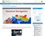
In this activity, students explore the importance of charts to navigation on …
In this activity, students explore the importance of charts to navigation on bodies of water. Using one worksheet, students learn to read the major map features found on a real nautical chart. Using another worksheet, students draw their own nautical chart using the symbols and identifying information learned.
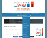
Slow Reveal Graph (#slowrevealgraph) is an instructional routine that promotes sensemaking about …
Slow Reveal Graph (#slowrevealgraph) is an instructional routine that promotes sensemaking about data. This highly engaging routine uses scaffolded visuals and discourse to help students (in K-12 and beyond) make sense of data. As more and more of the graph is revealed, students refine their interpretation and construct meaning, often in surprising ways. This routine increases access for students without sacrificing rigor or engagement.
You will find all types of graphs for all ages of learners from elementary to high school.
Here are the steps: - It starts with a graph that has been stripped of context: its numbers, its labels, its title. - The teacher facilitates a discussion around what students notice and wonder. (The slides give discussion suggestions) - Then another slide is revealed. - Students identify what information is new. - Then another slide is revealed. - Again, students identify what information is new (the title) and discuss how this changes their understanding of the graph. - As more slides are added, more insight into this data representation is revealed.
The introductory page for the graph also offers more information about the context for this graph, other content connections, and paired texts for students to explore.
No restrictions on your remixing, redistributing, or making derivative works. Give credit to the author, as required.
Your remixing, redistributing, or making derivatives works comes with some restrictions, including how it is shared.
Your redistributing comes with some restrictions. Do not remix or make derivative works.
Most restrictive license type. Prohibits most uses, sharing, and any changes.
Copyrighted materials, available under Fair Use and the TEACH Act for US-based educators, or other custom arrangements. Go to the resource provider to see their individual restrictions.